
Software


mAgri.RTK 90 is a modern RTK signal from the operator "Kyivstar" for agricultural, geodetic, and land management works with centimeter accuracy. As an official integrator, we offer you a ready-made solution for efficient and accurate operation of your GNSS equipment throughout Ukraine.
mAgri.RTK 30 is a modern RTK signal from the operator "Kyivstar" for agricultural, geodetic, and land management works with centimeter accuracy. As an official integrator, we offer you a ready-made solution for efficient and accurate operation of your GNSS equipment throughout Ukraine.
mAgri.RTK 365 StarLink Subscription — is a modern RTK correction service from the Kyivstar operator, enhanced by the ability to use satellite Internet connectivity. This solution ensures stable reception of RTK corrections even when terrestrial mobile network infrastructure is unavailable or operating unstably.
mAgri.RTK 365 is a modern RTK signal from the operator "Kyivstar" for agricultural, geodetic, and land management works with centimeter accuracy. As an official integrator, we offer you a ready-made solution for efficient and accurate operation of your GNSS equipment throughout Ukraine.

X-Survey Android software is a low-cost solution that will allow you to carry out professional geodetic services, work with points, measure distances, create electronic maps, stake-out, survey.

The Walker RTK with geometer mobile app is a compact and easy-to-use ideal tool for 3D surveying manholes, sidewalks, curbs, steps, landscaping, mapping trenches, and underground utilities such as electricity, gas, water, and sewer lines.

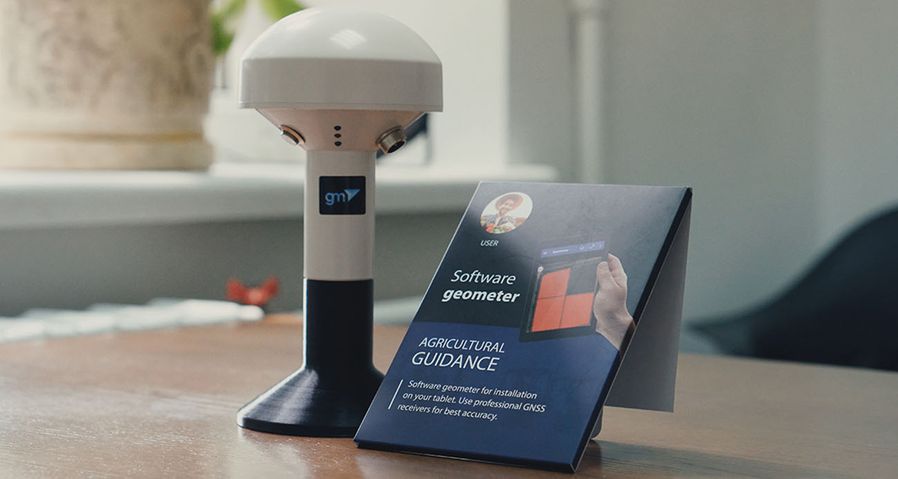
Agricultural mobile application geometer SCOUT for Android smartphone or tablet. A low-cost solution that will allow you to carry out area measurement of any shape, measure distances, create electronic maps, staking-out, land surveying, cutting out unproductive areas (holes) and many other operations.

Bundle: GM PRO S single-frequency GNSS receiver and geometer SCOUT software for field area measurement (Smoothing mode + RTK L1) is the optimal kit for accurate measurements (measurement of area, distances, work with points). The GM PRO S external GNSS receiver is used to improve the sensitivity and quality of the GPS/GNSS signal.

SurPAD 4.2 Android software is a low-cost solution that will allow you to carry out professional geodetic services, work with points, measure distances, create electronic maps, stake-out, survey.

Bundle: Dual-frequency GNSS receiver GM PRO U and geometer SCOUT application for stakin-out and precise measurements. This is the optimal set for accurate measurements (measurement of area, distances, accurate points). The GM PRO U receiver is used to obtain centimeter positioning accuracy.

The Agroprofile platform reveals the huge potential of using GPS / GNSS devices, complementing their functionality with an agricultural work planner, extended information about each field, GPS control of the location of agricultural equipment and much more.

GeoTrack Nova helps operators perform field work faster, more accurately, and with fewer overlaps. The application supports all major guidance modes required for spraying, fertilizer application, seeding, inter-row cultivation, tillage, harvesting, and many other agricultural operations.

Geotrack is the low-cost GPS guidance mobile application for Android devices which supports all tractor related field works such as spraying, fertilizing, plowing harvesting and sowing. Along with the software, geotrack users can purchase highly accurate GNSS and RTK solutions which provide smoothed guidance and centimeter accuracy.

Real-time GNSS (RTK) network package for 1 month. Includes functions from a single base station - "nearest" and network solutions - Automax, I-Max, VRS.

Real-time GNSS (RTK) network package for a quarter (3 months). Includes functions from a single base station - "nearest" and network solutions - Automax, I-Max, VRS.

Real-time GNSS (RTK) network basic package for 6 months. Includes functions from a single base station - "nearest" and network solutions - Automax, I-Max, VRS.

Real-time GNSS (RTK) network package for a year (12 months). Includes functions from a single base station - "nearest" and network solutions - Automax, I-Max, VRS.

The Agro RTK package includes connection to the GNSS base station network for one month. Provides the ability to connect agricultural machinery to the RTK signal of the network of base stations.

The Agro RTK package includes connection to the GNSS base station network for three months. Provides the ability to connect agricultural machinery to the RTK signal of the network of base stations.
The Agro RTK package includes connection to the GNSS base station network for six months. Provides the ability to connect agricultural machinery to the RTK signal of the network of base stations.

The Agro RTK package includes connection to the GNSS base station network for one year. Provides the ability to connect agricultural machinery to the RTK signal of the network of base stations.

The kit of equipment: agricultural mobile application geotrack with a GM SMART receiver. This is the optimal kit that will allow you to create your own agricultural guidance system (tractor gps, sprayer gps) with stable accuracy of 15 cm from pass-to-pass.

Digitals software provides automation of surveying work from processing field measurements to creating exchange files, cadastral plans and technical documentation. Does not require additional programs such as AutoCAD or MapInfo. Creates graphic and text documents based on templates, allowing you to automate the process and easily adapt it to any requirements

A geodetic software application designed for working with GNSS equipment on Android-based devices.
Geometer SCOUT is the Android mobile application for Precision Farming, which was developed for agronomists and farm managers. The first generation of the software was in development since 2010 for the Windows Mobile platform. Since 2016 we offer Android mobile application geometer.
Along with the software, geometer users can purchase highly accurate GNSS and RTK solutions which provide decimeter and centimeter accuracy.
In the new versions of the application, in addition to the basic functions, we are focusing on a deeper study of information about the state of soil and plants. Observation of crop development and growth is the main source of information on the state of crops. Thanks to the geometer SCOUT application,you can not only work with exact field areas, but also record the phytosanitary state of plants, take photographs with reference to fields and coordinates,fix сentre of diseases, pests and weeds.
Geotrack is the low-cost GPS/GNSS guidance mobile application for Android devices which supports all tractor related field works such as spraying, fertilizing, plowing harvesting and sowing. The first generation of the software was in development since 2011 for the Windows Mobile platform. Since 2016 we offer Android mobile application geotrack.
Each application receives constant updates and new features. Existing users can upgrade their application to the new most current version for free.