
Land has always been a valuable resource and the basis of economic and domestic relations, and its distribution and accounting for their foundation. As never before, in Ukraine there is a need to carry out land management work after the transfer of land to the status of a commodity.This led to a sharp increase in applications for land surveying, which caused an increased demand on service organizations providing geodetic services. In such a conditions, surveying engineers must have reliable equipment in their arms that will increase their productivity, be reliable and easy to use.
What equipment are used for geodetic surveying
Previously, works on resolving boundary disputes, installing a fence or drilling wells was carried out mainly using electronic total stations, which gave sufficient accuracy to perform such work. Nevertheless, the speed of working with them depended primarily on the qualifications of the specialist, and only then on the technical characteristics of the device.
From the point of view of a client, it does not make much difference which device the surveyor uses, the main thing is the result and the relevant documents received. As for the engineer surveyor the instrument that he uses in his work is of great importance. And here the key is not only the accuracy of the device, but also the speed of working with it, the convenience of processing the results, and even its weight. Because the time that will be spent on the survey of the land will depend on this. Today, time-tested electronic total stations are gradually being replaced by new geodetic instruments - GPS RTK kits, which, with the development of a network of base RTK stations, are becoming increasingly popular for accurate measurements of land.
What are GNSS RTK kits and what advantages do they have over total stations
First, let's figure out what RTK is and how important it is for measurement accuracy.
RTK is a system (method) for obtaining coordinates and heights of the terrain with centimeter accuracy using a satellite navigation system and receiving corrections from an RTK base station.
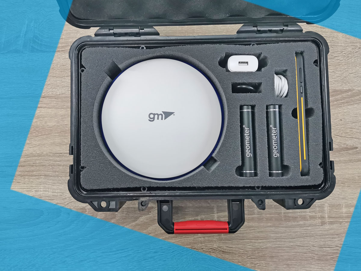
The standard package of geodetic instruments operating with RTK accuracy includes the RTK receiver itself, which receives coordinates from the base station, a controller with software, a tripod, a pole and additional accessories (batteries, chargers, holders, carrying case, etc.). The entire set operates under the control of specialized software installed on the controller and allowing you to manage the received data.
As a controller, both specialized devices of the same name and extremely secure smartphones can be used. The advantage of the latter is that they have the ability to upgrade the software to newer versions and use faster software with advanced features.
RTK receivers also have some differences from each other. There are dual-frequency and multi-frequency, which can support a different number of channels. More complex and, accordingly, expensive models have a tilt correction (the so-called IMU sensors), but they are not actually used for geodetic tasks for surveying a land plot and other similar works.
Which GNSS RTK kit to choose for land surveying and mapping
For professional purposes, the choice should be guided by specialized RTK receivers that work with GNSS corrections networks, if there is a need to check your own land, without an official document, you can also consider single-frequency receivers operating in DGPS mode (Enhanced Free Signal) or RTK L1 with which you can connect to the network of GNSS corrections.
You should also pay attention to the controller and the software installed on it. If the device is equipped with a specialized controller, then it is almost 100% guaranteed that the software on it will no longer be the newest version, it may have a foreign interface, and you will need to pay extra for expanding functionality. In this case, it is better to prefer rugged smartphones running a new version of the operating system and receive specialized software updates.
In Ukraine, there is a wide range of GNSS RTK kits for geodetic work, well-known foreign manufacturers and national industry leaders, such as the Geometer company.
We offer reliable GNSS RTK kits with dual-frequency and multi-frequency receivers for high-precision geodetic work, which will cope with any of the tasks:
- Surveying
- Binding points to terrain
- Stake-out
- RTK survey
- Measurement of small areas
- Mapping
- Accounting for work performed
- Determining the area of land
- Determination of distances
- Save coordinates
- Verification with maps of the StateGeocadastre
All Geometer GNSS RTK kits are equipped with a rugged smartphone with geometer or Survx proprietary software installed.