
Comparison of field area measurement with GM Spike external GNSS receiver, smartphone, and GNSS RTK device. Test Case.
12.08.2022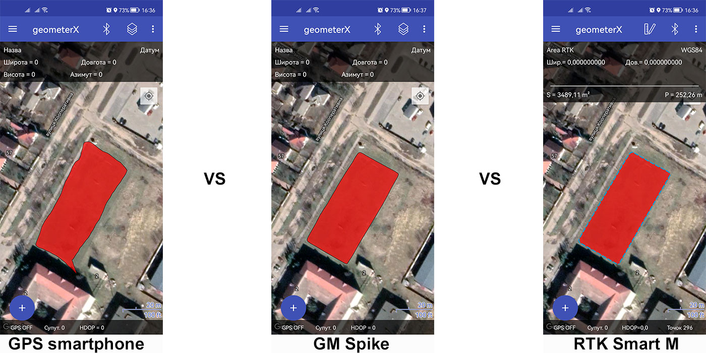 Purpose of the test
Compare the accuracy of measuring land area using the built-in GPS smartphone receiver, external GNSS receiver GM Spike and RTK receiver GM Smart M to identify the most accurate and optimal device to perform work on measuring the area of land areas.
Test area
Rectangular shape with smooth relief. On one side borders with a forest belt height of 8-10 meters.
Weather
Sunny weather with no clouds.
Measurement devices
Test 1
- External GNSS receiver GM Spike + smartphone Redmi note 8 Pro with the GeometerX application installed. Connecting the external receiver to the smartphone via Bluetooth.
- Redmi note 8 Pro smartphone with built-in GPS receiver + GeometerX app installed.
Test 2
External GNSS/RTK receiver GM Smart M + smartphone Redmi note 8 Pro with the GeometerX application installed. Connecting the external receiver to the smartphone via Bluetooth.
Measurement technique
Walking around the perimeter counterclockwise at an average pace with the start and finish at a fixed point. Two attempts were performed for each test to increase the reliability of the results obtained.
Execution of Test 1
The goal was to compare the accuracy of land area measurement with a smartphone with a built-in GPS receiver and a smartphone with an external GNSS receiver GM Spike, connected to a smartphone via Bluetooth.
Testing 1
When traversing the perimeter using a smartphone and the built-in GPS receiver, there was a visible degradation of the route line from the real one. This is due to the lower power of the built-in GPS receiver and unstable signal retention. Especially this degradation is clearly visible on the side of the site, which is adjoined by a forest belt, obstructing the stable reception of the GPS signal.
The contour of the area measured with the GM Spike GNSS receiver is equal, without deviations, even on the part of the area adjacent to the forest belt.
The results of test 1, testing 1
Smartphone with a built-in smartphone GPS receiver:
- Calculated area: 0,338 ha
- Perimeter: 272,81 m
- Inaccurate contour on all sides
Smartphone with external GNSS receiver GM Spike:
- Calculated area: 0,353 ha
- Perimeter: 251,23 m
- Correct and smooth contour
Testing 2
The contours of the field when measured using a smartphone and the built-in GPS, which also testing 1, are significantly degraded and not smooth. The measurement with the GM Spike GNSS receiver showed an equal and stable repeatable result.
The results of test 1, testing2
Smartphone with a built-in smartphone GPS receiver:
- Calculated area: 0,366 ha
- Perimeter: 268,34 m
- Inaccurate contour on all sides
Smartphone with external GNSS receiver GM Spike:
- Calculated area: 0,353 ha
- Perimeter: 251,61 m
- Correct and smooth contour
Conclusions of Test 1
Comparison of the results obtained on testing 1 and testing 2
|
Parameters |
Hectares |
Sq. m |
Perimeter, m |
|
Testing 1, smartphone |
0,338 |
3375,24 |
272,81 |
|
Testing 1, GM Spike |
0,353 |
3527,25 |
251,23 |
|
Testing 2, smartphone |
0,366 |
3662,73 |
268,34 |
|
Testing 2, GM Spike |
0,353 |
3531,18 |
251,61 |
|
Difference (testing 1, testin 2) smartphone |
0,028 |
287,49 |
-4,47 |
|
Difference (testing 1, testing 2) GM Spike |
0,000393 |
3,93 |
0,38 |
A comparison of the measurement results shows consistent repeatability when using an external GNSS receiver for area measurements, which showed almost complete overlap between testing 1 and testing 2. In contrast to the external receiver, the smartphone's built-in GPS receiver showed significant deviations in measurement between testing 1 and testing 2, which makes it impossible to rely on it to make accurate area and distance measurements.
Execution of Test 2
The goal was to calculate the area and perimeter of the test field using the high-precision GM Smart M GNSS/RTK receiver with a connection to the RTK network as the most accurate measurement method taken as a reference in the comparison.
The contours of the area when measured with the GM Smart M RTK receiver are equal and smooth, visually without deviations.
Отримані результати по Тесту 2
Smartphone with external GNSS receiver GM Smart M in RTK mode:
- Calculated area: 0,349 ha
- Perimeter: 252,26 m
- Correct and smooth contour
Overall conclusions from tests 1 and 2
Results
|
Parameters |
Hectares |
Sq. m |
Perimeter, m |
|
GNSS RTK |
0,349 |
3489,11 |
252,26 |
|
GM Spike |
0,353 |
3527,25 |
251,23 |
|
Built-in GPS smartphone |
0,338 |
3375,24 |
272,81 |
|
Differences GNSS RTK and GM Spike |
-0,004 |
-38,14 |
1,03 |
|
Differences GNSS RTK and built-in GPS smartphone |
0,011 |
113,87 |
-20,55 |
Analysis of the obtained results shows that the GNSS GM Spike receiver has minimal deviations from the reference RTK results, which conform to the declared technical specifications. The site contours are equal and smooth, almost identical to those obtained with the RTK receiver.
The results obtained when measuring with the smartphone's built-in GPS receiver showed significant deviations from both the reference results and the results obtained with the GM Spike.
Hence, we can conclude that measuring with the smartphone's built-in GPS receiver is not suitable for accurate measurements and can only be used for rough area and perimeter calculations and approximate positioning.
Using an external GM Spike GNSS receiver significantly improves the accuracy of area, perimeter, and distance measurements and is very close to the accuracy of an RTK receiver.