
Cube RTK GNSS receiver with surveying X-Survey software


Cube RTK GNSS receiver with surveying X-Survey software
- Online Payment
- Payment by Invoice
- Bank Transfer
- Air Mail Delivery
- Delivery via DPD
- Delivery via DHL
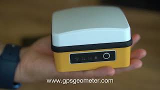
Surveying Kit: Multi-frequency GNSS RTK Receiver Cube RTK and X-Survey Geodetic Software for Android
Cube RTK - This geodetic kit is designed for high-precision point staking, parcel demarcation, cadastral surveys, and topographic mapping with exceptional horizontal and vertical accuracy. The kit includes professional-grade equipment and advanced geodetic software, making it an affordable and effective choice for professionals.
❗️❗️❗️To obtain centimeter accuracy, you need to use RTK corrections.
The receiver has 1408 channels and works with the following satellite systems and frequencies:
- GPS: L1 C/A, L1C1, L2P, L2C, L5
- GLONASS: L1, L2
- Galileo: E1, E5a, E5b
- BeiDou: B1l, B21, B31, B1C, B2a, B2b1
- QZSS: L1, L2, L5
Key Features GNSS Cube RTK:
- Cube RTK Receiver: Provides accuracy up to 10 mm horizontally and 20 mm vertically in RTK mode.
- X-Survey Software for Android: Allows easy management of measurement processes, data processing, and result export.
Advantages of GNSS Cube RTK:
- High measurement accuracy suitable for a wide range of geodetic tasks.
- Affordable kit that includes both equipment and software.
- Ease of use and compatibility with Android devices.
GNSS Cube RTK Kit Includes:
- GNSS receiver Cube RTK
- Permanent license for X-Survey
- Charging cable
- Carrying bag
- Cardboard packaging
- Portable case (optional)
The GNSS Cube RTK kit is ideal for professionals involved in cadastral work, topographic surveys, and other geodetic tasks requiring high accuracy and reliability.
-
Dimensions (mm):104x104x65
-
Weight (kg):0,45
-
Manufacturer country:China
-
Accuracy:8 mm
-
Number of channels:1408
-
Positioning horizontal accuracy:8 mm + 1 ppm
-
Positioning vertical accuracy:15 mm + 1 ppm
-
Sattelite systems:GPS, BeiDou, GLONASS, Galileo
-
Frequency:1-5 Hz
-
Range of working temperatures:-20℃ ~ 70℃
-
Bluetooth:5.2
-
Power supply :Battery
-
Ingress Protection:IP65
-
mount:Thread 3/8" (5/8 adapter included)
-
Battery life:up to 8 hours
-
Tilt Compensation IMU:Yes
-
Laser:No