

Meridian M27LV GNSS RTK Receiver: What Are the Two Cameras and Laser Used For?
07.10.2026
- Conventional RTK Surveying
- The Laser: Measuring a Point Without Placing the Pole on It
- So What Are the Cameras For?
- The AR Camera for Visual Stakeout
- Another Useful Capability: Photogrammetry
- How Photogrammetry Works, in Simple Terms
- What Is the Difference Between Laser Measurement and Photogrammetry?
- A Practical Example
- Another Key Technology: The IMU
- Working with M-Survey
- Why Two Cameras Instead of One?
- Does It Replace a Total Station?
- The Meridian M27LV Is More Than an RTK Receiver
Modern GNSS RTK receivers have long been capable of much more than simply determining the coordinates of the point beneath a survey pole. A good example is the Meridian M27LV, which features two cameras, a laser rangefinder, and an IMU.
At first glance, this raises an obvious question: why does a GNSS receiver need cameras and a laser when its primary job is to obtain precise coordinates from satellite signals?
These technologies address different practical challenges. The laser allows you to measure points that are difficult or impossible to reach with a survey pole. The cameras assist with stakeout and enable photogrammetric measurements.
Let’s take a straightforward look at how it all works.

Conventional RTK Surveying
Let’s start with the traditional approach.
The surveyor mounts the GNSS receiver on a survey pole, places the pole tip directly on the point to be measured, and records its coordinates.
When the receiver is receiving RTK corrections and has a fixed RTK solution, it can determine coordinates with centimetre-level accuracy.
This method works well as long as the point is physically accessible.
But imagine you need to measure:
- a building corner behind a fence;
- a point on a building facade;
- the edge of a roof;
- the centre of a manhole cover in a roadway;
- a point beyond a barrier;
- an object in a hazardous area;
- a location where placing a survey pole is simply impossible.
This is where the additional capabilities of the Meridian M27LV become useful.

The Laser: Measuring a Point Without Placing the Pole on It
The laser is perhaps the easiest feature to explain.
In conventional RTK surveying, the receiver determines the coordinates of the point beneath the pole tip.
With a laser, you can take a different approach.
For example, you may need the coordinates of a building corner that you cannot reach because of a fence.
You stay in a convenient position, aim the Meridian M27LV’s laser at the corner, and take a measurement.
At that moment, the receiver knows:
- its own precise RTK coordinates;
- its orientation in space, provided by the IMU;
- the direction of the laser beam;
- the distance to the target, measured by the laser.
Using this information, the software can calculate the coordinates of the point targeted by the laser.
Put simply:
RTK determines where the receiver is → the IMU determines which way it is pointing → the laser measures the distance → the software calculates the target point’s coordinates.
This allows you to measure points from a distance when placing the pole directly on them would be difficult or impossible.
So What Are the Cameras For?
The Meridian M27LV has not one, but two cameras.
This is where things get particularly interesting, because the cameras do much more than take photographs.
One camera function supports visual stakeout (the AR camera), while the other supports photogrammetric measurements (the VR camera).
These are two different workflows.

The AR Camera for Visual Stakeout
Imagine a typical surveying task.
Your project contains a point with known coordinates, and you now need to locate and mark it on the ground — a process known as stakeout.
In a conventional workflow, the software displays instructions such as:
1.35 m forward → 0.42 m to the right.
The surveyor moves the pole, follows the arrows, and gradually approaches the target point.
The Meridian M27LV can use its camera to make this process more intuitive.
The controller screen displays a live view of the site from the receiver’s camera, with guidance towards the design point overlaid on the image.
It is essentially augmented reality for surveyors.
Instead of constantly interpreting arrows and numbers, the operator can see which direction to move.
This is especially useful when the target point is some distance away.

Another Useful Capability: Photogrammetry
Photogrammetry works very differently from laser measurement.
The easiest way to explain it is with a practical example.
Imagine a building in front of you.
You need to determine the coordinates of several features:
- the left and right corners;
- the doorway;
- the windows;
- a specific point on the facade.
With a conventional RTK receiver, you would have to visit each accessible point individually.
With a laser, you would also measure the points one at a time:
Aim → measure → aim at the next point → measure.
Photogrammetry offers a different approach.
How Photogrammetry Works, in Simple Terms
The operator moves in front of the object and photographs it from several different positions.
For example:
📷 Position 1 → BUILDING ← Position 2 📷
Then:
📷 Position 3 → BUILDING
The photographs show the same building features from different angles.
Meanwhile, the Meridian M27LV knows the receiver’s precise coordinates and orientation at the time each image is captured.
The software can match information across multiple images and use geometry to determine the object’s position in space.
This is similar to the way we perceive depth using two eyes.
Our eyes see the same object from slightly different angles, and our brain uses that difference to perceive depth.
Photogrammetry uses a similar principle, but instead of two eyes, it uses photographs taken from different, precisely known positions.
What Is the Difference Between Laser Measurement and Photogrammetry?
These technologies may seem similar because both let you measure points from a distance. However, they work in different ways.
A laser is useful when you need to measure a specific point quickly:
Identify the point → aim the laser → take a measurement → obtain the coordinates.
For example, you might need the coordinates of a single building corner behind a fence.
In this case, the laser offers a straightforward solution.
Photogrammetry is particularly useful when you need to measure many points on the same object:
Photograph the object from several positions → generate photogrammetric data → select the points you need to measure.
For example, instead of measuring ten facade features one after another, you can capture the images first and then work with the resulting data.
This is why the laser and camera complement each other.
A Practical Example
Let’s consider another situation.
A surveyor is standing outside a fenced private property.
The task is to determine the coordinates of a building corner inside the property.
Option 1 — conventional RTK.
You need to enter the property and physically place the pole tip on the required point.
Option 2 — laser measurement.
If the building corner is clearly visible, you can stay outside, aim the laser at it, and measure it from a distance.
Option 3 — photogrammetry.
If you need to measure several building features rather than a single point, you can photograph the building from different positions and then determine the required points from the captured data.
The best choice depends on the task.
Another Key Technology: The IMU
To support these capabilities, the Meridian M27LV uses an inertial measurement unit (IMU).
It determines the receiver’s tilt and orientation in space.
The IMU is also useful in conventional RTK surveying.
Without tilt compensation, the operator must keep the pole as close to vertical as possible.
With an IMU, the receiver can account for the pole’s tilt and calculate the coordinates of the pole tip.
This speeds up fieldwork, especially when collecting a large number of points.
For measurements taken from a distance, knowing the receiver’s orientation becomes even more important.
Working with M-Survey
The Meridian M27LV is operated using its dedicated M-Survey software.
M-Survey is a specialised version of X-Survey, adapted for Meridian equipment.
The software integrates communication protocols for all Meridian GNSS receiver models, giving the operator access to standard GNSS positioning as well as the supported features of each specific model.
This matters because the hardware and software need to work together.
The cameras, laser, IMU, and photogrammetry capabilities are more than a collection of separate hardware features. Making full use of them requires integration between the receiver and its software.
M-Survey provides the tools for receiver configuration, RTK surveying, stakeout, and access to the Meridian M27LV’s advanced features.
Why Two Cameras Instead of One?
The Meridian M27LV’s design now makes more sense.
The cameras serve different purposes.
One supports AR visual guidance, helping the operator navigate to a design point during stakeout.
The other supports photogrammetric surveying, turning the camera into a measurement tool that captures spatial information about objects.
Together with the laser and IMU, these features turn the GNSS receiver into a much more versatile system, extending its capabilities beyond the traditional “place the pole and record the coordinates” workflow.
Does It Replace a Total Station?
Not entirely.
GNSS RTK, laser measurement, photogrammetry, and total stations each have their own strengths and limitations.
The Meridian M27LV is particularly useful because it extends the capabilities of GNSS surveying without requiring additional equipment in many everyday situations.
Some tasks that previously required finding a way to place the pole physically on a point can now be completed from a distance.
And when you need to survey multiple features on the same object, photogrammetry offers another option.
The Meridian M27LV Is More Than an RTK Receiver
In simple terms, the Meridian M27LV’s main technologies serve the following purposes:
GNSS RTK — provides precise coordinates.
IMU — determines the receiver’s tilt and orientation, allowing measurements with a tilted pole.
Laser — lets you measure individual, hard-to-reach points from a distance.
AR camera — provides visual guidance to help you locate a design point during stakeout.
Camera and photogrammetry — allow you to determine the coordinates of points on objects using images captured from different positions.
M-Survey brings these capabilities together in a single working environment and provides the tools to control Meridian equipment.
It is this combination of technologies that sets the Meridian M27LV apart.
This is more than a GNSS RTK receiver for measuring the point beneath a survey pole. It is a tool that lets you choose the most practical measurement method for each situation: conventional RTK surveying, tilt-compensated measurements, laser measurements from a distance, or image-based measurements using photogrammetry.
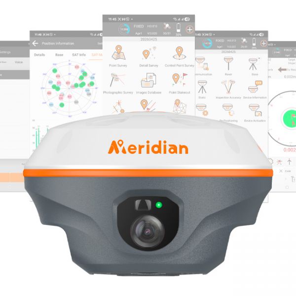
Meridian M27LV is a versatile GNSS RTK surveying receiver for topographic surveys, cadastral and construction applications, stakeout, and the measurement of hard-to-reach objects.
By combining satellite positioning, a laser rangefinder, two cameras, and IMU tilt compensation, it lets you choose the most practical measurement method for each task. You can survey with an upright or tilted pole, measure individual points with the laser, or determine their coordinates from photographs.