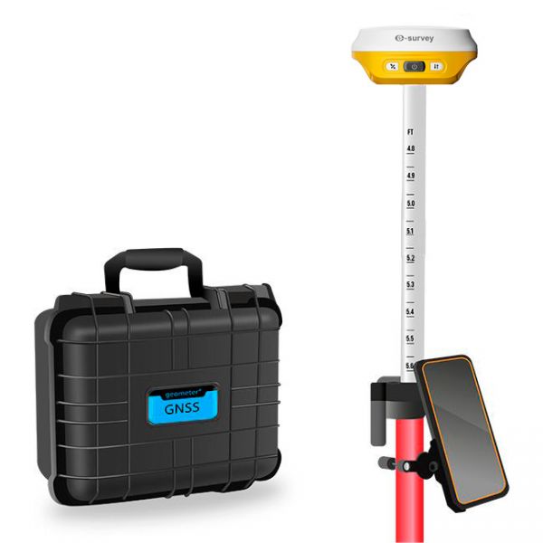
Multifrequency GNSS RTK eRTK10 mini KIT
Multifrequency GNSS RTK eRTK10 mini KIT
- Online Payment
- Payment by Invoice
- Bank Transfer
- Air Mail Delivery
- Delivery via DPD
- Delivery via DHL
GNSS RTK Kit eSurvey eRTK10 mini KIT — Compact, Accurate, Efficient
eSurvey eRTK10 mini KIT is a modern GNSS solution that combines high precision, versatility, and user-friendliness in an ultra-lightweight body. Designed for professionals who value mobility and speed, this kit provides stable positioning in a wide range of conditions — from open fields to urban streets and hard-to-reach locations.
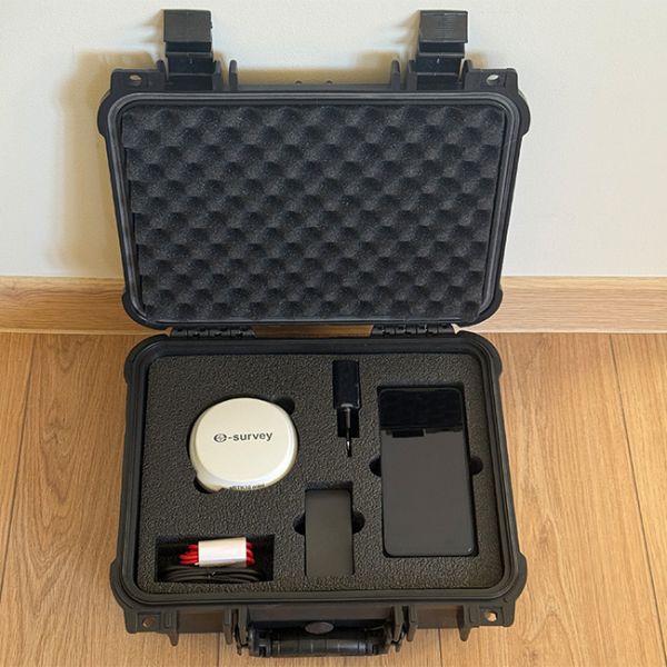
Package Contents:
- eRTK10 mini GNSS Receiver
- Rugged Android Smartphone
- SurPad 4.2 Software
- 2.5 m Survey Pole
- Pole Smartphone Holder
- Power Adapter
- USB Type-C Cable
- Warranty Card
- Carrying Bag
- Carrying Case (optional)
Who is eRTK10 mini KIT for?
This kit is an excellent choice for:
-
Surveyors
-
Land Management Specialists
-
Cadastral Engineers
-
Construction Crews
-
Precision Farming Professionals
Multi-frequency and Multi-constellation Support
The receiver supports all major satellite systems (GPS, GLONASS, Galileo, BeiDou) on L1/L2/L5 frequencies, enabling fast RTK fix and high real-time positioning accuracy.
Tilt Compensation up to 60° without Accuracy Loss
The IMU module allows measurements with up to 60° tilt, simplifying work in challenging environments — on slopes, in narrow areas, or near buildings. No need to perfectly level the pole — tilt is automatically compensated by the technology.
Voice Notifications
Intelligent voice prompts notify the user about the current operation mode, solution status changes, and battery level — a great help during fast-paced fieldwork without checking the screen.
Remote Control via Web Interface
Users can configure modes, check receiver status, download data, or update firmware through the web interface from any smartphone, tablet, or laptop.
Support for PPP Galileo HAS
With support for the Galileo HAS service, the receiver can achieve up to 20 cm accuracy without base stations or Internet connection. This is ideal for remote areas with poor mobile network coverage.
Rugged Housing, Ready for the Field
The magnesium alloy body is rated IP67, resistant to drops, dust, moisture, and other harsh conditions. The receiver is certified for operation in extreme environments.
Maximum Productivity — Minimum Effort
eSurvey eRTK10 mini KIT is a next-generation tool that enables accurate surveying without complex setup. With its thoughtful configuration, compact size, and user-friendly interface, you have everything you need for efficient work right from the start.
Full Integration with SurPad 4.2
Thanks to full compatibility with SurPad 4.2, users can access a powerful toolbox for project management, coordinate input, data logging, processing, and report export — all fast, easy, and convenient.
-
Dimensions (mm):98*45.5
-
Weight (kg):2.5
-
Manufacturer country:China
-
Accuracy:8 mm
-
Number of channels:1408
-
Positioning horizontal accuracy:8 mm + 1 ppm
-
Positioning vertical accuracy:15 mm + 1 ppm
-
Frequency:GPS: L1 C/A, L2C, L2P, L5 BeiDou: B1, B2, B3 BeiDou Global Signal: B1C, B2a, B2b GLONASS: L1 C/A, L1P, L2 C/A, L2P Galileo: E1, E5a, E5b, E6, E5 AltBOC QZSS: L1C, L2, L5, L1C/A IRNSS: L5 SBAS: WAAS, EGNOS, MSAS, GAGAN,SDCM L-Band1
-
Range of working temperatures:-30 ℃ ~ + 65℃
-
Bluetooth:5.0
-
Cold start:< 30 sec
-
Warm start:< 20 sec
-
Hot start:< 5 sec
-
RAM:8 Gb
-
Communication standard support:2G/3G/4G/WiFi
-
Ingress Protection:IP67
-
Battery life:up to 12 hours
-
Tilt Compensation IMU:Yes
-
AR Camera:Yes. It is used for augmented reality (AR) stakeout


