
Geotrack lite agricultural guidance system RTK L1/L2


Geotrack lite agricultural guidance system RTK L1/L2
- Online Payment
- Payment by Invoice
- Bank Transfer
- Air Mail Delivery
- Delivery via DPD
- Delivery via DHL
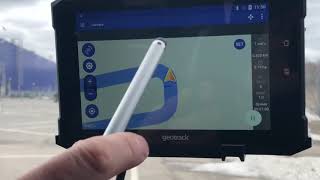
Agricultural guidance system geotrack Lite RTK L1/L2 is based on Samsung's 8.7-inch display with LTE, geotrack software and dual-frequency GM SMART receiver L1/L2. This is a low-cost agricultural guidance system with RTK that works with an accuracy of up to 2.5 cm. The dual-frequency GM SMART receiver has 698 channels to work with all available satellite systems: GPS, GLONASS, GALILEO, BEIDOU, QZSS, SBAS. To get centimeter accuracy, you need RTK corrections or your own base station.
The geotrack lite RTK guidance system can work in two modes:
- Coordinate smoothing mode on a free satellite signal with an accuracy of 15 cm from pass-to-pass.
- RTK absolute centimeter accuracy mode.
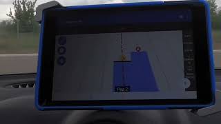
The system displays information for precise guidance of the equipment, records the trajectory of the equipment in the form of a track and accurately calculates the cultivated area. Thanks to the licensed geotrack software, working with this kit will be convenient and easy. It has an intuitive menu, so it does not require special training of the operator.
Synchronization of fields and works via Wi-Fi/3G/4G/LTE with the Agroprofile portal will greatly facilitate work with the device and provide the possibility of remote control of workers who are in the field.
The agricultural GNSS RTK guidance system is suitable for such works as sowing, spraying plants against weeds and pests, application of mineral and organic fertilizers. The joint use of the GM SMART receiver and the geotrack program makes it possible to accurately control agricultural machinery in the field in conditions of poor vision - at night, in fog, in conditions of heavy dust.
Pass-to-pass accuracy:
Supported operating systems and software:
Operating system:
Android
version 9.0 and above
Application:
Geotrack
Equipment:
- Tablet 8.7 inches with LTE
- Receiver GM SMART RTK L1/L2
- Mobile application geotrack
- Protective Case for Tablet
- Professional Tablet Mount
- RAM Mount
- Magnetic holder for GNSS receiver
- 12V cigarette lighter adapter
Functionality:
- Absolute precision of agricultural guidance
- Absolute precision of area measurement
- Treatment of saved fields
- Determining the treated area
- Visualization of the treated area
- Displaying the movement speed
- Displaying azimuth
- Five guidance patterns
- Adjustment of width of equipment (to centimeters)
- Online technical support
- Saving a field map
- Automatic saving works
- Specifying Job Types (sowing, spraying, etc.)
- Support for RTK L1
- Optional support for RTK L1/L2
- Online sync with Agroprofile
Operating modes:
- Area measurement
- Area measurement with offset
- Free guidance mode
- Straight A-B
- Curve A-B
- Perimeter - Straight A-B
- Perimeter - Curve A-B
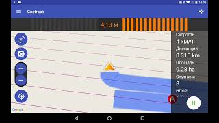
What data is displayed while driving:
- Treated area
- Travelled length
- Speed of movement
- Number of satellites
- Satellite signal quality (HDOP)
- Visual guidance tips
- Calculation of working time
- Count overlapping
- Visualization of overlapping
- Ratio: work done / in process
Useful links
- Free farm management system Agroprofile
- Learn more about Agroprofile
Quality control of field works
The new geotrack software has many functions to determine the quality of work: displaying the treated area, visualization of overlapping in a darker color. The system automatically captures the quality of field processing in real time.
Fuel economy
Accurate parallel guidance between rows will allow not to return to the treated areas for their completion. Field processing will be more controlled and accurate.
Save time and money
The agricultural guidance system is able to work at any time of day or night, in any weather, in fog, dust and poor visibility.
Saving herbicides and seeds
The agronavigator will allow to control precisely equipment between passes that will allow to distribute accurately and economically herbicides, sowing materials and other resources during field works.
Full synchronization with the office
This navigation kit has a built-in WI-FI module. With the help of wireless data transmission agronavigator will be constantly in touch with the online account Agroprofile. The manager will be able to monitor the progress of work in real time. The whole eco-system from the GeoMeter company allows you to change the quality of preparation and execution of works for the better.
Online technical support
It is very important to receive technical support from the supplier at the right time. Developers from GeoMeter company has taken this into account in its new development: devices with geotrack software can be tested and maintained using remote access, a company specialist will be able to connect to your display without leaving the field. To use this feature, you need an Internet connection via Wi-Fi.

-
Weight (kg):1.6 kg
-
Manufacturer country:Ukraine
-
Accuracy:2,5 cm
-
Screen size:8,7 inches (22 cm)
-
GNSS receiver type:GM Smart
-
Brand:geometer
-
Number of channels:698
-
Sattelite systems:GPS, BeiDou, GLONASS, Galileo, QZSS, SBAS
-
Frequency:10 Hz
-
Bluetooth:4.2
-
RAM:8 Gb
-
Integrated memory:128 Gb
-
Power supply :Battery
-
Communication standard support:2G/3G/4G
-
Ingress Protection:IP67
-
mount:Neodymium magnet

Multi-frequency GNSS RTK base station L1, L2, L5.

Geometer Power Station is a lithium-ion battery in an aluminum body with a capacity of 3400 mAh. This is a useful accessory for GNSS receivers and GeoMeter devices, which will allow you to get extra charge in the field.

Agricultural mobile application geometer SCOUT for Android smartphone or tablet. A low-cost solution that will allow you to carry out area measurement of any shape, measure distances, create electronic maps, staking-out, land surveying, cutting out unproductive areas (holes) and many other operations.