
GNSS Receiver GM SPIKE 2 for Area Measurement


GNSS Receiver GM SPIKE 2 for Area Measurement
- Online Payment
- Payment by Invoice
- Bank Transfer
- Air Mail Delivery
- Delivery via DPD
- Delivery via DHL
An entry-level navigation kit designed for basic agricultural tasks.
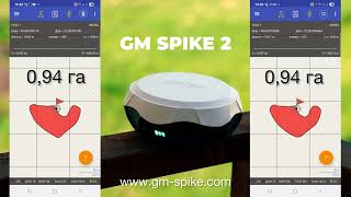
The kit includes the second-generation GNSS receiver GM SPIKE 2 and the geometer SCOUT agricultural application for area measurement. This is an optimal solution for accurate measurement of field areas, distances, and point positioning. The external GNSS receiver with antenna ensures improved accuracy, high sensitivity, and stable GPS/GNSS signal reception even in challenging conditions.
PACKAGE INCLUDES:
- GM SPIKE 2 GNSS receiver with built-in battery;
- geometer SCOUT software;
- Magnetic mount for the receiver;
- Carrying and storage case.
Geometer SCOUT is a proprietary Android application with specialized tools for field measurement and positioning. It enables precise positioning, accurate area and distance measurements, 3D measurement, point staking, coordinate storage and input, digitizing orchards and other objects, field marking, cutting out areas, and adding new objects. All operations are performed via a touchscreen interface. The app features an intuitive menu and does not require special training.
Synchronization of fields and operations via Wi-Fi/3G/4G/LTE with the Agroprofile portal significantly simplifies workflow and allows automatic transfer of measurement data to the free online platform www.agroprofile.com for convenient planning and monitoring of agricultural activities. This allows you to store all your fields and work data in one place and manage operations more efficiently.
FUNCTIONAL FEATURES:
- Measurement of small areas
- Point positioning and mapping
- Field mapping
- Instant display on Google Maps
- Pass counting for wide equipment
- Connection of external devices via Bluetooth
- Soil compaction measurement support (penetrometer)
- Field splitting
- Area cutting (exclude zones)
- Field marking
- Area calculation
- Distance measurement
- Synchronization with Agroprofile
Area measurement accuracy:
Point positioning accuracy:
Additional Information
- Product page: geometer SCOUT
- Download user manual
- Free online platform Agroprofile
Resolving Field Area Disputes
With the geometer SCOUT app and GM SPIKE 2 GNSS receiver, you can easily avoid disputes related to field size. For example, if a contractor claims a field area of 12 hectares, but fuel consumption suggests otherwise, you can simply walk or drive around the field perimeter and instantly obtain an accurate map and exact area. Using Agroprofile, you can also generate a detailed field report. For higher precision, an RTK receiver may be required.
Data Security and Team Collaboration
The geometer SCOUT application installed on an Android device provides a personalized working environment. Log in to your Agroprofile account and synchronize your fields. Share notes and data with colleagues within your organization. Data exchange is performed via a secure protocol. Your data remains protected, and access is restricted. Additional device security options include PIN, facial recognition, or pattern lock.
Penetrometer Integration
The geometer SCOUT app can connect to external devices via Bluetooth/BLE. When used with a digital penetrometer, soil density data is recorded alongside measurement points. Results are displayed as graphs and stored for reporting. All data can be synchronized with Agroprofile for full history tracking and advanced reporting.
Data Transfer and Cloud Integration
Agroprofile is designed to work seamlessly with Android devices and the geometer SCOUT app. It allows real-time data synchronization between team members, secure storage of field data, and 24/7 access. Data can be exported in multiple formats including KML, UTM, MGRS, TXT, CSV, and user-defined datum formats.
Field Splitting
The intuitive interface of geometer SCOUT allows easy field division into multiple zones. Simply tap on the screen to split the field according to your needs. You have full control over how the field is divided.
All Functions in One Tap
The geometer SCOUT software combines simplicity and powerful functionality. Its new logic allows multiple operations to be performed with a single tap — including area measurement, field division, and exclusion of non-productive zones. Additional features include field marking, optimal route planning, semi-automatic circle creation for irrigation systems, RTK mode support, and real-time display on Google Maps.

-
Weight (kg):0.250
-
Manufacturer country:Ukraine
-
Accuracy:~ 1.0 - 1.5 m
-
GNSS receiver type:GM Spike
-
Brand:geometer
-
Number of channels:72
-
Sattelite systems:GPS, Galileo, Glonass, Beidou
-
Frequency:1-5 Hz
-
Bluetooth:5.0
-
Power supply :Battery, 5V, 2A
-
Ingress Protection:IP65
-
mount:1/4" thread
-
Battery life:up to 15 hours
-
Tilt Compensation IMU:No
-
Warranty:1 year
-
Laser:No